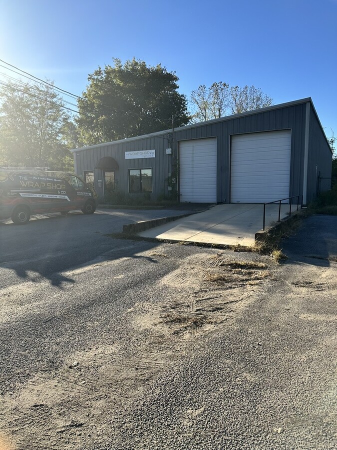
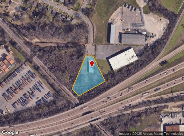
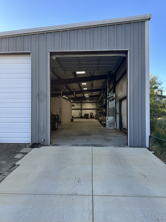
Property Record
3055 Southwall St, Memphis, TN 38114
Current Lease Availabilities
NEARBY LISTINGS FOR SALE OR LEASE
Property Detail
3055 Southwall St
Memphis, TN-MS-AR
Inmans Interstate Industrial Park
07-3087-0-0004
SS SOUTHWALL ST TO I-240 R.O.W.
Warehouse
Shelby
X
Tennessee
47157C0430F
2&pt3
0
1.86 AC
2024
Southeast
008120
Memphis
6,619 SF
DEMOGRAPHICS near 3055 Southwall St
1 Mile
3 Mile
5 Mile
2024 Total Population
6,711
77,127
214,206
2029 Population
6,870
78,338
215,329
Pop Growth 2024-2029
+ 2.37%
+ 1.57%
+ 0.52%
Average Age
38
37
38
2024 Total Households
2,726
30,669
88,103
HH Growth 2024-2029
+ 1.80%
+ 1.43%
+ 0.38%
Median Household Inc
$32,572
$33,965
$42,057
Avg Household Size
2.40
2.40
2.30
2024 Avg HH Vehicles
1.00
1.00
1.00
Median Home Value
$57,376
$76,852
$149,580
Median Year Built
1956
1958
1959
Nearby Places
- Restaurants
- Banks
- Shops
- Fitness
- Groceries
PUBLIC TRANSPORTATION
COMMUTER RAIL
Central Station (Riverfront Loop - Memphis Area Transit Authority Trolley (MataTrolley))
DRIVE
WALK
Distance
Central Station (Riverfront Loop - Memphis Area Transit Authority Trolley (MataTrolley))
14 min
7.8 mi
AIRPORT
Memphis International
DRIVE
WALK
Distance
Memphis International
9 min
5.0 mi
Freight Ports
Port of Shreveport
DRIVE
WALK
Distance
Port of Shreveport
409 min
375.2 mi
Nearby Properties
Address
Land Use
TOTAL SIZE
Lot Size
Zoning
Address
Land Use
TOTAL SIZE
Lot Size
Zoning
838,318 SF
39.56 AC
I-L
Address
Land Use
TOTAL SIZE
Lot Size
Zoning
189,536 SF
49.14 AC
CMU-2
Address
Land Use
TOTAL SIZE
Lot Size
Zoning
118,116 SF
60.70 AC
CMU-2
Address
Land Use
TOTAL SIZE
Lot Size
Zoning
180,831 SF
13.11 AC
EMP
Address
Land Use
TOTAL SIZE
Lot Size
Zoning
52,688 SF
24.38 AC
CA
Address
Land Use
TOTAL SIZE
Lot Size
Zoning
2,847.82 AC
EMP
Address
Land Use
TOTAL SIZE
Lot Size
Zoning
118,073 SF
4.75 AC
CMU-1
Address
Land Use
TOTAL SIZE
Lot Size
Zoning
76.64 AC
RU-1
Address
Land Use
TOTAL SIZE
Lot Size
Zoning
188,458 SF
29.18 AC
RU-3
Address
Land Use
TOTAL SIZE
Lot Size
Zoning
1,760,826 SF
109.47 AC
EMP
Address
Land Use
TOTAL SIZE
Lot Size
Zoning
58.21 AC
R-6
Address
Land Use
TOTAL SIZE
Lot Size
Zoning
55,250 SF
7.15 AC
CMU-3
Address
Land Use
TOTAL SIZE
Lot Size
Zoning
129 AC
CMP-1
Address
Land Use
TOTAL SIZE
Lot Size
Zoning
1,117,337 SF
127.15 AC
EMP
Address
Land Use
TOTAL SIZE
Lot Size
Zoning
66,841 SF
7.86 AC
CMU-3
Address
Land Use
TOTAL SIZE
Lot Size
Zoning
81,454 SF
EMP
Address
Land Use
TOTAL SIZE
Lot Size
Zoning
509,111 SF
EMP
Address
Land Use
TOTAL SIZE
Lot Size
Zoning
81,958 SF
0.98 AC
CMU-1
Address
Land Use
TOTAL SIZE
Lot Size
Zoning
414,189 SF
16.71 AC
R-6
Address
Land Use
TOTAL SIZE
Lot Size
Zoning
73,168 SF
1.38 AC
CMU-1
Address
Land Use
TOTAL SIZE
Lot Size
Zoning
1,012,609 SF
38.67 AC
IH
Address
Land Use
TOTAL SIZE
Lot Size
Zoning
369,190 SF
23.75 AC
EMP
Address
Land Use
TOTAL SIZE
Lot Size
Zoning
56,848 SF
1.61 AC
EMP
Address
Land Use
TOTAL SIZE
Lot Size
Zoning
300,011 SF
17.53 AC
EMP
Address
Land Use
TOTAL SIZE
Lot Size
Zoning
72,060 SF
1.02 AC
CMU-1
Address
Land Use
TOTAL SIZE
Lot Size
Zoning
306,219 SF
12.11 AC
EMP
Address
Land Use
TOTAL SIZE
Lot Size
Zoning
71,308 SF
EMP
Address
Land Use
TOTAL SIZE
Lot Size
Zoning
173,089 SF
10.92 AC
EMP
Address
Land Use
TOTAL SIZE
Lot Size
Zoning
82,595 SF
4.54 AC
CMU-3
Address
Land Use
TOTAL SIZE
Lot Size
Zoning
97,223 SF
0.89 AC
CMU-2
The World's #1 Commercial Real Estate Marketplace
Connect with us
© 2025 CoStar Group
The information above has been obtained from sources believed reliable. While we do not doubt its accuracy we have not verified it and make no guarantee, warranty or representation about it. It is your responsibility to independently confirm its accuracy and completeness. Any projections, opinions, assumptions, or estimates used are for example only and do not represent the current or future performance of the property. The value of this transaction to you depends on tax and other factors which should be evaluated by your tax, financial, and legal advisors. You and your advisors should conduct a careful, independent investigation of the property to determine to your satisfaction the suitability of the property for your needs.